12.28.2013

New Dungeness Lighthouse Membership


Recently I made a membership purchase!! I decided to be an member of the New Dungeness Lighthouse!
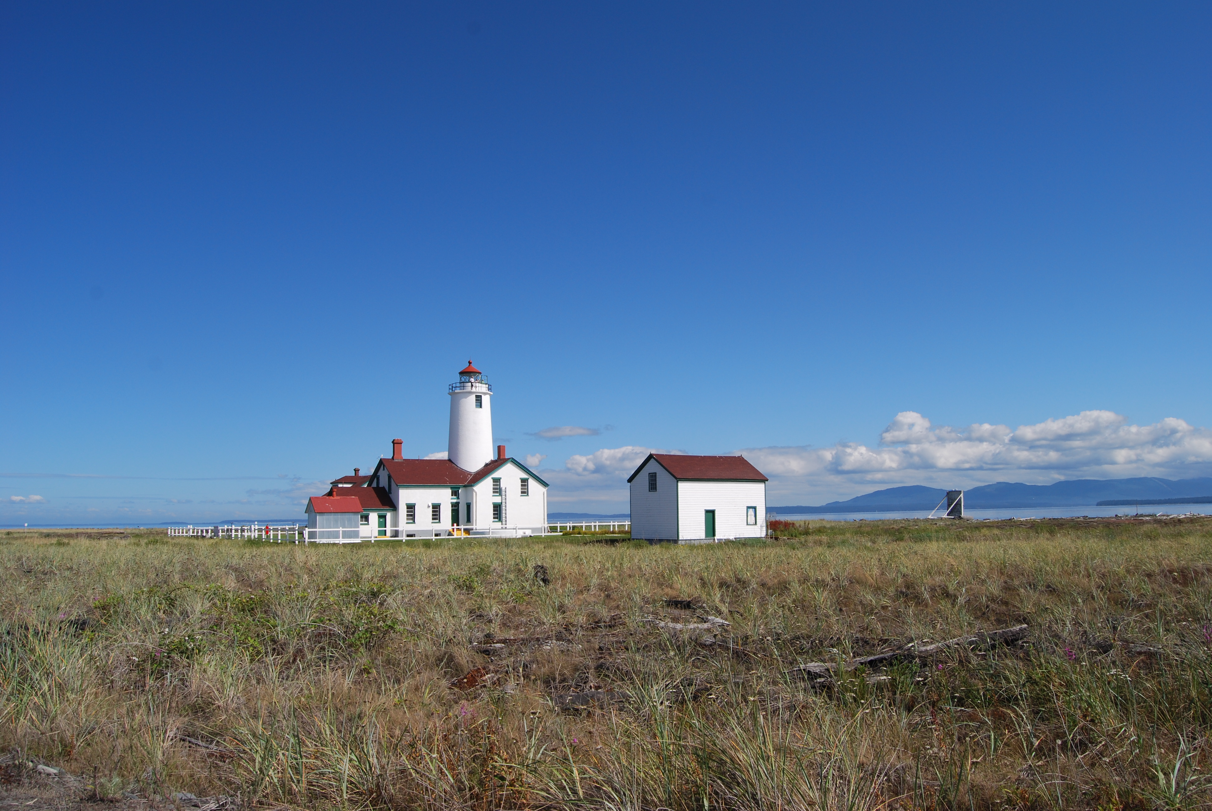
The lighthouse is located on the tip of the Dungeness National Wildlife Refuge. One of the world's longest natural sand spit. Its near Sequim, Washington on the Strait of Juan de Fuca.

Why you may ask?
All members are able to rent the lighthouse out for a week for 350$ per adult or 50$ a day to cover short notice cancellations. Sounds fun? I agree but there's a catch. The renter must take on all daily tasks of the lighthouse including helping with Public Tours. SWEET! Still fun? I think so.
The money and chores help maintain the lighthouse while giving the public a fun educational community driven experience!!
Now i haven't tried this yet, so maybe it only sounds fun but i can't wait to find out in 2014! I hope to have a full blogpost about my experience this year.
Membership is an annual amount of 35$ per person or 50$ household.Here's a link the the Lighthouse Keepers quarters slideshow.
http://www.newdungenesslighthouse.com/gallery-Keepers-Quarters.html


My Membership Card
 

                           Membership cd which comes in the packet

More info:

http://www.newdungenesslighthouse.com/

http://newdungenesslight.org/weather/

http://en.wikipedia.org/wiki/New_Dungeness_Light

12.25.2013

Lake of the Angels: Olympic National Park (Putvin Trail)

Looking NE from Lake of the Angels

In bed I leaned over my left  shoulder to glance at my phone. Crap, its 10am already. I slept in. Its Friday and i have the day off.  Jumping out of bed sunbeams are streaming into my room! It's not raining!!!! Score!!
Quickly my backpack is packed with gear and extra clothing. The civic peels off of the gravel sidewalk and quickly I'm navigating towards the Olympic National Park!
I wanted to try my chances hiking the Lake of the Angels trail, otherwise know as the "Putvin Trail"! I had hiked the trail last September (2014) on a rainy and windy day where low clouds blocked all views that surrounded the lake. But today was clear, cold but clear with barely a cloud in  the sky.


Mt Rainier from Hamma Hamma River Valley, el. 3,,500 ft
 
No car was parked in the trail parking lot! Score! Solitude, even though the mountains seem to keep me from being lonely!!
With my running shoes on i cruised up the trail with my boots in my pack expecting snow in the alpine.
Northface of Mt Jefferson
 
Soon running came to a halt and hiking became the norm.
Just above 3,500 feet, the no fire zone, the alpine became visible. An alder meadow presented itself as a creek swiftly flew the meadow. Above the meadow elevation quickly ran straight up allowing waterfalls to fall. One such waterfall was half ice. 
Next the steepest climb began! At a couple points the hike turns into rock climbing where at one point climbing rope has been tied to a tree trunk to pull oneself up. Soon after this, alpine is near and views looking across the hamma hamma river reveal the craggy cliffy ridge of Mt. Jefferson.
 

Jefferson Ridge

 
The trail continued but this time with snow. I decided to not take a break and trudge through with my Adidas running shoes. Deeper and deep it became with about a foot deep at its deepest.The lake was frozen over with exception to the mouth where a fast creek was bubbling.

Lake of the Angels

 
I made it to the lake after sunset which was very disappointing! At least the sky was blue, snow pristine, and the views were capturing!! Worth it the effort!
After switching to the boots and eating some carrots and hummus for a snack the trail was underfoot again.
Darkness came half way down the trail and soon the comfort of the car encompassed me. If only i could do it all over again tomorrow!


Frozen pond


Sunset


11.23.2013

Nisqually Wildlife Refuge, Washington State


Its Sunday and its fall/winter in Tacoma which means RAIN!! If you live on the westside of Washington you know that you have to accept the neverending rain in order to get outside!
Being couped up for sometime indoors I jumped in my car and headed south to the Nisqually Nat' Wildlife Refuge.

                                      marsh/wetland
Upon arriving the parking lot to my amazement was almost packed. The sweet lady at the desk alerted me that a Great Horned Owl had been spotted the last couple days.
The gift store is nice with lots of birding books along with wildlife books. I grabbed a list of all the birds that either call Nisqually refuge their home or just pass by. The list was quite long.
 

                                                                        The estuary
The refuge is almost all boardwalk. There are also trails next to the boardwalk and a trail that connects the marsh boardwalk to the estuary boardwalk.
The estuary boardwalk goes far out into the estuary where high tide will surround on all sides.
Birds were everywhere especially in the estuary portion. Waterfowl were plentiful. I wish i had brought my binoculars as i probably would have been able to cross off more birds on my list.
The Northern Harrier made his rounds above the estuary twice as i walked. Each time he flew low the waterfowl would scatter beneath him. It was life he was just having fun showing everyone who was the boss.
Two eagles were seen playing with each other or possibly mating. I don't know when their mating season is but i know that eagles mate for life!
I never saw the Great Horned Owl but i did see a couple seals in the Nisqually river overlook.
The rain came and went. Soon my patience with it took a steep decline. I cut short the estuary boardwalk and took to the car for heat and warmth.
It was still far better than staying home!!


                                         Bubbles from clams
                                                                             Blue Heron
 
Birds spotted: Blue Heron, Mallard, Canadian Geese, Buffleheads, American Wigeon, Northern Shoveler, Northern Pintail, Hooded Merganser, Northern Harrier, Bald Eagle, American Coot, Belted Kingfisher, Winter Wren

Here's more info and facts about NWR:
http://www.fws.gov/refuge/nisqually/
http://friendsofnisquallynwr.org/
http://en.wikipedia.org/wiki/Nisqually_National_Wildlife_Refuge

11.14.2013

Lake Mowich Loop: Part II

Mt Rainier from Spray Park
 

Morning came but not fast enough as I struggled to stay asleep the second half of the night. Another bright sunny day laid ahead. 
Soon camp was behind me and Mt Rainier was waiting for me!
On the way up Spray Park Trail creeks, waterfalls and more creeks flowed over and adjacent to the trail. Wildflowers popped up everywhere! This is what I had been waiting for!!!!


Snow soon covered the trail as Mt. Rainier slowly revealed her glacier capped head. Mother mountain and her craggy ridge protected my back to my south as I slowly hiked through an ice field. Once up the snowfield Rainier was is full view. This was the highest point of Spray Park Trail but instead of heading to lower elevation I had to get closer to Rainier's Spectacular vastness. An off-trail path headed closer to Rainier. Alpine wildflowers were blooming everywhere. After a 1000 foot climb I sat in the warming glaring sun eating lunch as I starred at the snowy giant. 
 
 I've seen Mt Rainier while driving north and south on I-5 and while hiking in Clearwater Wilderness but this trumps all other views. Up close and personal!!!! I took out my topo map of Rainier and studied its peaks, glaciers, ridges, cliff faces and its topography just like I love to analyze my GF's beautiful eyes and face!!! Minutes smeared into an hour!! Pure relaxing enjoyment!!
   Off down the trail i passed many day hikers who were heading up. I met a threesome from the Czech Republic who spoke of only the respect they had for Mt Rainier. So glad it's in my back yard!!
Through the lush water soaked alpine fields of spray park I quickly hiked. Avalanche lilies were so abundant that it was as if the ground was snow covered! 
 
Into the trees I walked while taking the side trail to see Spray Falls.
I was not expecting to see and experience what laid infront of me!
I'd never heard of Spray Falls therefore i didn't know what to expect. Its shear cliff face with a robust amount of beautiful cascading water had me sudennly sitting down and head turned up in amazement! Mist slowly swirled around my body giving the experience an fantasy land like feel! 
Snack-time!! 
After cooling off in the mist I journeyed the rest of the way back to my old VW golf. Another trek, another adventure, another wonderful weekend in the PNW!!


10.31.2013

Lake Mowich Loop: Mt Rainier National Park


Summer was in full force as July came and went trying to quickly run away and I hadn't ventured out for my first backpacking trip of 2013. Sad but true!!
 
I had to get outside and do some solo backpacking. I picked Mt Rainier National Park. Earlier in the year I ventured into the National Park for my first time as a day hike to Green Lake. Now for my first backpacking trek! 


I started my one night solo trek at Lake Mowich. The trail took me over Ipsut pass and down into the Carbon River valley.
Ipsut pass was full of wildflowers in full bloom with bumblebees and several species of butterflies zipping all around me. I felt a warm welcome from the park that day. 
Once to the Carbon River I headed upstream then crossed the river on a detour as my planned trail was taped off due to trail erosion from the river. As I crossed the river my first eyeful of Mt Rainier sat in front of me!! Awe Inspiring!!
A mile up the trail a group of trail workers passed me by.

Soon I came to the swinging bridge but before I swung across I sat my pack down and hiked up another 1/2 mile to view the great Carbon Glacier.
The glacier was not what i thought it would look like. It was a dark gray color with weeds and plant life on top of it. I guess i expected more of a white snow color. The glacier was huge with the Carbon River raging out from under the glacier. It was awe inspiring to encounter. The river valley which I had been hiking up was now fully understood as i could see how such valley could be formed by the juggernaut Carbon Glacier.


Back down to the trail i crossed over the swinging bridge which crossed over the carbon river. I pasted the carbon river camp knowing it would be very popular with the wonderland trail hikers and settled down in Cataract valley camp. I had the whole campsite to myself. The camp was pleasant with a large creek running through the middle of it and plenty of trees for my hammock. A full meal of Bear Creek Potato Soup (just add h2o) and i was in bed and sound asleep. Just over 10 miles all in all!!


Lake Mowich Lake part two is coming soon!


9.22.2013

North Mt Rainier Video

Here's a video i made showing Mt Rainier's north face along with several of the north slopes key prominent points . The video was shot near the Spray Park Trail in Mt Rainier National Park. Thanks to my trusty pointer the video is 100% PROFESSIONAL!! lol
This video is based off my trusty map so please comment if I'm off on anything!

9.13.2013

Spray Falls Video

 
This amazing  354 foot waterfall is only a couple miles from Lake Mowich trailhead. Its definately worth a day hike to marvel at  along with cooling off with all the spray from the falls. Hence the name Spray Falls!

Here's a website with info about the falls!
http://www.waterfallsnorthwest.com/nws/falls.php?num=5419

8.22.2013

The Beardslee Trout

taken from http://www.fishingphotos.net/photopost/showphoto.php/photo/2694/title/beardslee-trout-2c-lkcrescent-2c-wa/cat/502


On a recent trip into the majestic Olympic National Park i heard about a native Trout i'd never heard of before. A ranger at the Hurricane Ridge Visitor Center told me about the Beardslee Trout.
My question which started the conversation was actually about the Brook Trout found in Grand Valley, a popular hiking destination in the park. The conversation turned to the range sharing about the only native lake trout found in the park, The Beardslee!!
The Ranger went on to tell me that trout ran up from the Strait of Juan De Fuca to Lake Cresent at one time. A huge landslide cut off the route up to the lake creating two lakes: Lake Cresent and Lake Sutherland. Lake Sutherland was at one time apart of Lake Cresent . The trout which were in Lake Cresent at the time became landlocked and became a subspecies of trout.
The Beardslee Trout is still in the lake today though the population has slowly decreased. Simply fascinating!!!
I hope to one day catch one of these "Bluebacks" as their called.
Take from http://www.washingtontrout.org/crescent.shtml

The text above was all info from the ranger, below is info i found on the web.


http://www.washingtontrout.org/crescent.shtml

http://en.wikipedia.org/wiki/Beardslee_trout
http://www.craigmagnuson.com/beardslee.htm
://httpwww.youtube.com/watch?feature=player_embedded&v=nccb1F_koKE

8.20.2013

Moose lake Brook Trout


Moose lake Brook Trout in 2013
This last Saturday i headed up to Grand Valley in the North Olympic National Park for a two night stay at moose lake. With fishing pole in hand i packed in a couple lures for some spin casting.
Three beautiful fish were caught. All three were Brook Trout. The bellies of these fish are slight red to deep red. It almost looks like their bleeding from the hook in their mouth until you reel them in closer.
I love packing in a light fishing set up with low weighted test line to feel these guys fight.
The teeth on these reds are quite impressive for small 6 to 8 inch trout. One can feel a little pain and last year one fish actually drew blood from my thumb.
After the hike out i stopped by the Hurricane Ridge Visitor center for a quick question about the brookies in the Olympic National Park's Moose lake and other lakes. Are they native?
Nope their not.
How did they get their?
The Ranger told me that they think someone planted them their. He said catch as many as you want!
What about other lakes?
Nope, no native brooks in any lakes.
There's one native Trout though, the Beardslee Trout!!!
More coming on the Beardslee!


Brook Trout caught by Jeff Wheeler from moose lake in 2012


6.24.2013

Sorry for DISAPPEARING!!

It's been awhile since I've posted on my blog! So long that..... well I can't remember the date of my last post! 
I wanted to say thanks if you've noticed!! 
Be encouraged, posts will be coming in the coming two weeks! 
Life has been busy but enjoyable and even though the blog has been dry I haven't stopped exploring the outdoors!!! 
Posts to come: Climbing Mt St Helens, Green Lake (Mt Rainier), Mt Eliinor and Drift Creek Falls!
See ya soon!!  

2.22.2013

Top Three Free Iphone Tidal Apps


With access to millions of instant information at our fingertips our phones are increasingly valuable. Smartphones have potential to make our lives easier and more productive.They also can make our lives more complex and less social but that's a whole different blog arena.
If your like me and live near a U.S. coastline you may need or simply want a good solid tide app for quick reference!!
Well i did the work for you!! You can thank me later.
I looked at 7 free apps and picked my top three fave's!!
The good, the bad and the ugly combined (the 7 apps):
TideDataFree, Tides, Tides...Free, Sea Tow, Tides:...Free, Tides Planner and Tides Weather. These names were taken from each app's icon. All were a penny short of a penny...free!!

The background picture is my two month old nephew! I had to so him off somehow!

The 7 tidal apps are shown on the top of the picture.
I wanted to find out which app was the best and easiest to use. I don't go to the beach regularly but visit enough to have a permanent app on my iPhone for good tide references.
My decision on which app was the best, was based off of two priorities: quality information and easy browsing!

After browsing through each app i decided on the top three apps. Here they are from best to third best: 1.Seatow, 2.Tide Data Free, 3.Tides Weather

Third Place:Tides Weather

Pros:
  - offers three day weather info
  - your home screen as tidal info for your location
  - Home screen can be saved to a specific location for weather
  - Can save tide station favorites
  - Tide graph easy to read
  - Info is in feet and meters
  - Offers a map
  - 10 day tide forecast
  - A nearby tide station list
  - search option and U.S. station list
 
Cons:
  - Map loads slowly
  - Seemed like map has less tide stations compared to other apps
  - no sunset, sunrise, moonrise or moonset times
  - browsing through app not as easy as others

Second Place: Tide Data Free

Pros:
  - Saved favorites
  - List of each states tide stations
  - Great map
  - Sunset, sunrise, moonrise and moonset times
  - Easy graph to read
  - Easy to browse and use
 
Cons:
  - Only a two day tide forecast

First Place: SeaTow

Pros:
  - 11 day weather forecast
  - Weather radar
  - 7 day tide forecast
  - moonrise and tells which quarter it's in
  - Map
  - Good graph
  - Saves up to 7+ locations on tide homescreen
  - Rotate screen for tide graphs
  - GPS/Compass
  - Meters or feet and miles or kilometers
  - Search option

Con:
  - Map only shows tide stations within a certain number of miles of your location. Example: if near the Puget Sound you can see all Puget Sound stations but cant see all  the Washington coast stations unless searched for.
  - No station list
  - Map doesn't always seem to have all surrounding stations.


Hope these reviews helped! Now that SeaTow is on my phone the tide forecast is seconds away!!Time to play in the sand!!